


Weesenstein circular route
Take a deep breath and find peace: What a healing effect well-tended parks and gardens have on us! There are several of them in Saxon Switzerland. A hidden gem is the park of Weesenstein Castle in the...
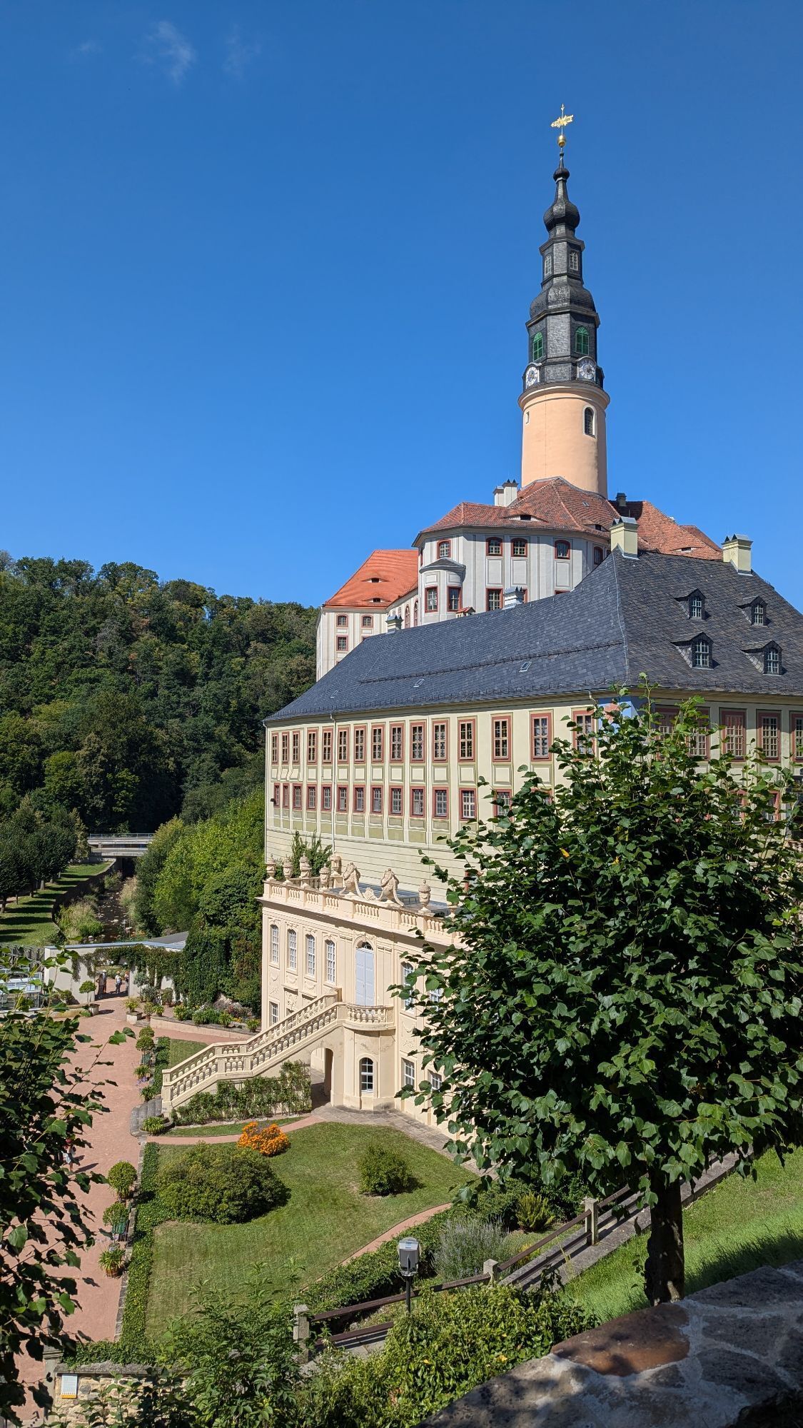
Take a deep breath and find peace: What a healing effect well-tended parks and gardens have on us! There are several of them in Saxon Switzerland. A hidden gem is the park of Weesenstein Castle in the Müglitz Valley. This jewel of historical garden culture is also the starting and ending point of the Weesenstein circular path and, with a running time of 1.5 hours, is ideally suited for a relaxing walk.
From Weesenstein Castle, the path first leads along the Planetenweg (Planet Path), always alongside the Müglitz River. There are interesting information boards about the planets at regular intervals. A short distance after crossing the level crossing, the path continues to the right into a valley up to Köttewitz. After a short stretch through the small village, past beautiful gardens, the path continues along a field path to a small wood. The subsequent descent back to Weesenstein Castle offers wonderful views down into the valley to the picturesque park.
At the end of the tour, of course, a visit to these grounds is not to be missed. Weesenstein Palace Park is not the product of a single, absolutist stroke of genius - as was the case with the garden artwork in Grosssedlitz - but of a long development spanning several centuries. Since the course of the Müglitz was changed in the meantime, the grounds have since been divided into a Small and a Large Palace Park. A bridge with King Johann's monogram connects the two parts. In the Small Palace Park, benches around a fountain and in a rhododendron grove invite visitors to linger. The Great Palace Park is characterised by avenues and an arcade leading to a pavilion. Eye-catchers are a statue of Flora, the goddess of flowers, and a marble column commemorating the golden wedding anniversary of King John and Queen Amalie Augusta.
Schloos Weesenstein - Planetenweg - Köttewitz - Brünnleinweg - Schloss Weesenstein
Winter hiking map Saxon Switzerland - edition with 35 selected winter hiking routes incl. winter refreshment stop
Wanderstöcke und Eisgrödel, die unter die Schuhe geschnallt werden, können die persönliche Geländetauglichkeit erhöhen. Im Tourist Service in Bad Schandau kann diese Ausrüstung ausgeliehen werden.
This hike is a red route (moderately difficult tour, with slight climbs, possibly difficult in deep snow).
From/to Weesentein: RB72, Bus 201
Weesenstein Castle car park
Parcours populaires à proximité
-
5,0
Basteibrücke
facileRandonnée 2,31 km -
5,0
Rauenstein von Weißig
moyenRandonnée 4,35 km -
4,5
Malerweg Etappe 1: Von Pirna-Liebethal nach Stadt Wehlen (offizielle Version TV Sächsische Schweiz)
facileRandonnée 11,6 km -
Trebnitzgrund à savourer (Glashütte)
moyenRandonnée 14,6 km -
5,0
Uttewalder Felsentor, Schwedenlöcher, Wehlen und zurück
moyenRandonnée 16,1 km -
3,8
Kurort Rathen - Schwedenturm - Schwedenscheibe - Schwarzer Berg
moyenRandonnée 10,5 km -
5,0
Pillnitzer Wälder und Weinberge
moyenRandonnée 6,67 km -
4,5
Malerweg, Etappe 7: Von Kurort Gohrisch bis Weißig (offizielle Version TV Sächsische Schweiz)
moyenRandonnée 16,7 km -
5,0
Leupoldishain Nikolsdorfer Wände: Napoleonstein - Felsenlabyrinth - Spanghorn
moyenRandonnée 11,2 km -
Maler Rundweg Sächsische Schweiz
facileRandonnée 12,3 km
Randonnée et suivi


Ne manquez pas les offres et l'inspiration pour vos prochaines vacances
Votre adresse électronique a été ajouté à la liste de diffusion.