


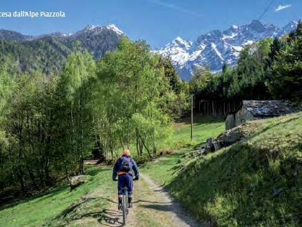
Castello dell' Acqua, Alpe Piazzola (MTB-EMTB)


This route is not particularly difficult, as its length, difference in altitude and gradients are feasible. It starts in the car park near the new sports centre in Castello dell'Acqua and follows the Sentiero...
This route is not particularly difficult, as its length, difference in altitude and gradients are feasible. It starts in the car park near the new sports centre in Castello dell'Acqua and follows the Sentiero Valtellina westwards to Ponte del Bahetto (Chiuro). From here you begin to climb on tarmac to the municipal square. Still on tarmac, you continue through several hamlets nestling among the chestnut woods. The last part over compact rough terrain brings you to the mountain chalets at Alpe Piazzola (holiday farmhouse), a large rise offering splendid views of middle Valtellina. The downhill route is different from the uphill one, and two short detours let you visit a watermill with horizontal blades, a pila, the ancient machine used for hulling chestnuts and cereals and an old blacksmith's forge.

RIF. BOSIO 2080M A.MASTABBIA 2098M A. GIUMELLINO 1775M A E LAGO PIRLO 1596M A. PRADACCIO 1723M PASSO VENTINA 2675M A. VENTINA (RIF. GERLI E PORRO E VENTINA) 1960M
Parcours populaires à proximité
-
4,3
Rifugio Curo’ e lago del Barbellino - lago naturale del Barbellino - lago Gelt
difficileRandonnée 26,4 km -
4,0
Valbondione-Curò
moyenRandonnée 7,02 km -
Bergwanderung zum «See des Verrückten» - Kurz Version
Randonnée 11,4 km -
33.10 Le Prese - Tirano, Via Albula / Bernina
moyenRandonnée 14,6 km -
Via Dei Terrazzamenti
moyenChemin de Grande Randonnée 74,1 km -
Il Sentiero delle Marmitte
difficileRandonnée 3,68 km -
5,0
Brunone
moyenRandonnée en montagne 15,0 km -
Miralago - Tirano Durch via Valposchiavo talauswärts nach Italien
Randonnée 11,7 km -
Rund Wanderung Cavaione-Giümelin-Cavione
moyenRandonnée 15,9 km -
Il Giro dell'Armisola
moyenVTT 17,2 km
Randonnée et suivi


Ne manquez pas les offres et l'inspiration pour vos prochaines vacances
Votre adresse électronique a été ajouté à la liste de diffusion.