Dates des itinéraires
20,23km
1.096
- 1.559m
288hm
684hm
06:43h
- Parcours
-
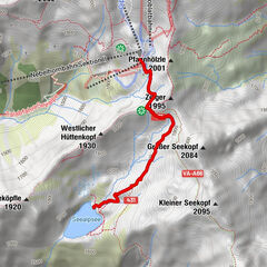
Warth (1.495 m)0,0 kmKitzeliftle0,1 kmGehren1,8 kmHl. Nikolaus1,8 kmSt. Wendelin3,2 kmLechleiten3,3 kmPrenten12,2 kmWelzau13,3 kmSerble13,9 kmKnopplig13,9 kmSt. Oswald14,1 kmSteeg (1.124 m)14,6 kmHotel Post14,8 kmDickenau14,8 kmHägerauer Wasserfall16,0 kmSt. Josef18,5 kmDürnau18,6 kmHolzgau (1.114 m)20,1 km
- Hauteur maximale
- 1.559 m
GPS Downloads


Autres parcours dans les régions