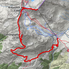
The scenic trail - from Lake Wiegensee to Verbellaalpe and through Ganifer Valley to Partenen

Chemin thématique


- Brève description
-
Summit station Tafamunt cable car- Lake Wiegensee - Verbellaalpe - Ganifer Valley - Partenen
- Difficulté
-
moyen
- Évaluation
-
- Parcours
-
InnertafamuntAlpstöbli Tafamunt0,0 kmPfarrkirche Partenen12,2 kmPartenen (1.051 m)12,4 km
- Meilleure saison
-
janv.févr.marsavrilmaijuinjuil.aoûtsept.oct.nov.déc.
- Hauteur maximale
- 1.937 m
- Point de mire
-
Valley station Tafamunt cable car, Partenen
- Profil en hauteur
-


-

-
AuteurLa randonnée The scenic trail - from Lake Wiegensee to Verbellaalpe and through Ganifer Valley to Partenen est utilisé par outdooractive.com fourni par.
GPS Downloads


Informations générales
Point de rassemblement
Secret
Flore
Faune
Prometteur
Autres parcours dans les régions
-
Montafon
1382
-
Gaschurn - Partenen
355