Au-Schoppernau | Diedamskopf - Falzerkopf

Logo Au-Schoppernau | Diedamskopf - Falzerkopf
Dates des itinéraires
9,47km
1.639 - 2.015m
Distance
675hm
328hm
Montée
04:30h
 
Durée
Brève description

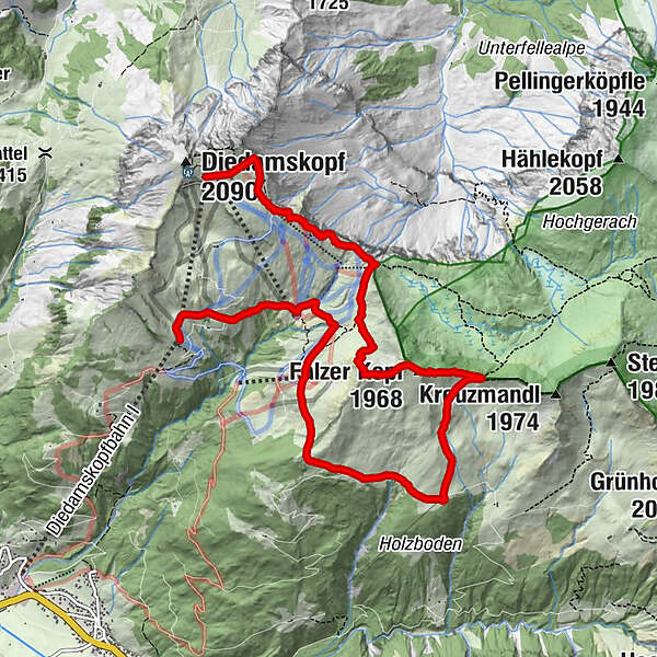
Mittelstation - Breitenalpe - Falzalpe - Neuhornbachhaus - Neuhornbachjoch - Falzer Kopf - Kreuzle - Bergstation

Difficulté
moyen
Évaluation
Technique
Endurance
Paysage
Résultat
Parcours
Breitenalpe
2,1 km
Neuhornbachhaus (1.700 m)
4,1 km
Diedamskopfbahn Bergstation (2.090 m)
9,2 km
Panoramarestaurant
9,2 km
Meilleure saison
janv.
févr.
mars
avril
mai
juin
juil.
août
sept.
oct.
nov.
déc.
Hauteur maximale
2.015 m
Point de mire

Diedamskopf Bergstation

Profil en hauteur

Auteur
La randonnée Au-Schoppernau | Diedamskopf - Falzerkopf est utilisé par outdooractive.com fourni par.

3,0
Évaluation globale

5

0

%

4

25

%

3

50

%

2

25

%

1

0

%

GPS Downloads
  • GPX GPS Exchange Format (XML)
  • KML Google Earth, Google Maps
Codes de téléchargement QR pour les téléphones portables

Informations générales

Point de rassemblement
Prometteur
Autres parcours dans les régions

Randonnées populaires dans la région

Hiking around the lake Spullersee

facile Randonnée
5,58km | 183hm | 01:56h

Faschina | Rund um's Zafernhorn

moyen Randonnée
10,09km | 634hm | 04:15h

Around Lake Formarin

difficile Randonnée
3,79km | 84hm | 02:06h

Damüls | Auf das Portlahorn

moyen Randonnée
9,62km | 533hm | 04:05h