Dates des itinéraires
18,45km
627
- 1.644m
1.064hm
02:00h
- Brève description
-
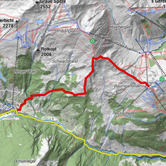
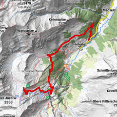
Mayrhofen Bahnhof - Ortsteil Kumbichl - Stilluptal - Grüne Wand Hütte - Materialseilbahn Kasseler Hütte
- Difficulté
-
moyen
- Évaluation
-
- Parcours
-
Mayrhofen im Zillertal0,0 kmMayrhofen (633 m)0,4 kmKumbichl1,3 kmGasthof Wasserfall9,1 kmAlpengasthof Stillupperhaus12,9 kmGrüne-Wand-Hütte16,4 km
- Meilleure saison
-
janv.févr.marsavrilmaijuinjuil.aoûtsept.oct.nov.déc.
- Hauteur maximale
- 1.644 m
- Repos/Rassembler
-
Alpengasthaus Lacknerbrunn, Alpengasthof Wasserfall, Stillupperhaus, Grüne Wand Hütte
- Cartes
-
Mountainbike-Karte hinteres Zillertal, Kompass Karte K037, Kompass Karte K37

GPS Downloads


Circuits
Asphalte
(15 km)
Gravier
(2 km)
Forêt
Sentiers de montagne
Sentiers singletrail
Trial
Circulation
Autres parcours dans les régions

")

 - Penkenjoch (2095 m)")