Villnöss Valley and Peitlerkofel/Sasso Putia - Dolomites - 2875m


- Brève description
-
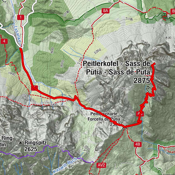
Classic tour on the top of Val di FaunesFillnöβtal
From Zannes Hut on the Sass da Putia/Pleiterkofel (also with snow-shoes)
Starting-point Rifugio Zannes/Zannser Alm (1670 mt.)
At a glance: Rifugio Zannes/Zannser Alm - Malga Gampen (Hut) - Rifugio Genova/Schlütterhütte - Sass da Putia/Pleiterkofel - return
Altitude difference: 1205 mt.
Highest point: Sass da Putia/Pleiterkofel (2875 mt.)
Duration: 7 hours
Length: about 14 km
Difficulty: five climbing-boots hike
Useful advice: hike suitable for well-trained people, with good pace and not suffering from dizziness. The hike takes to the top of a famous and isolated mount of the Dolomites, crowded on summer. Children and inexpert people should be protected by a roped-group. Watching the dawn from Sass da Putia/Pleiterkofel is an unforgettable experience,
- Parcours
-
Peitlerscharte (2.357 m)2,5 kmPeitlerkofel (2.875 m)4,4 km
- Hauteur maximale
- 2.855 m
- Profil en hauteur
-
 © outdooractive.com


- Auteur
-
La randonnée Villnöss Valley and Peitlerkofel/Sasso Putia - Dolomites - 2875m est utilisé par outdooractive.com fourni par.


-
Dolomiten
1808
-
Alta Badia
1045
-
Badia
333