Dates des itinéraires
20,84km
959
- 1.515m
704hm
08:00h
- Brève description
-
Weite aber sanfte Wanderung im Almenland.
- Évaluation
-
- Point de départ
-
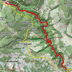
St. Kathrein am Offernegg (970m ü. NN)
- Parcours
-
Landgasthof Steinhauser0,1 kmSankt Kathrein am Offenegg0,1 kmDorf0,3 kmFeichteck (1.242 m)5,2 kmHuab-n & Greisslerei6,3 kmBrandlucken6,4 kmGasthof Zur schönen Aussicht6,4 kmHeilbrunn6,6 kmOffner Berg (1.293 m)8,4 kmStoakoglhütte10,9 kmPlankogel (1.531 m)11,7 kmHolzmeister16,9 kmTeichalm20,8 km
- Hauteur maximale
- 1.515 m
GPS Downloads


Nature du chemin
Asphalte
Gravier
Pelouse
Forêt
Rocher
Exposé
Autres parcours dans les régions
-
Hochsteiermark
4075
-
Naturpark Almenland
1766
-
St. Kathrein am Offenegg
476