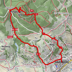
Hartberg - Eggendorf - Lungitz - Lafnitztal (Maierhofermühle)

Randonnée

- Brève description
-
An approx. 10 kilometre hike from Hartberg to Eggendorf, Unterlungitz to the Lafnitztal valley to the Maierhofermühle mill with the option of returning to Hartberg by bus. (Please note the timetable and opening hours of the restaurants along the route. They are closed on Mondays and Tuesdays).
- Difficulté
-
facile
- Évaluation
-
- Parcours
-
HartbergGasthaus Eggendorfwirt3,4 kmEggendorf3,4 kmUnterlungitz5,1 kmGasthaus Maierhofer-Mühle8,1 km
- Meilleure saison
-
janv.févr.marsavrilmaijuinjuil.aoûtsept.oct.nov.déc.
- Hauteur maximale
- 427 m
- Point de mire
-
Hartberg, bus station
- Profil en hauteur
-

- Auteur
-
La randonnée Hartberg - Eggendorf - Lungitz - Lafnitztal (Maierhofermühle) est utilisé par outdooractive.com fourni par.
GPS Downloads


Informations générales
Point de rassemblement
Culturel/Historiquement
Flore
Autres parcours dans les régions
-
Thermen- & Vulkanland
1324
-
Hartbergerland
830
-
St. Johann in der Haide
139