© Erlebnisregion Schladming-Dachstein - Roland Gutwenger

- Brève description
-
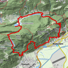
First four kilometers with only short climbs form the ideal warm-up phase before we overcome about 220 m in the Raumberg forest on forest and hiking trails and reach our highest point, the Obermoserhof. Here we are rewarded with a surprising panoramic view. The downhill on first asphalt and then forest hiking trails brings us back to the starting point via the Fischersteig.
- Difficulté
-
facile
- Évaluation
-
- Parcours
-
Raumberg3,8 kmSagschachengraben8,5 km
- Meilleure saison
-
janv.févr.marsavrilmaijuinjuil.aoûtsept.oct.nov.déc.
- Hauteur maximale
- 1.006 m
- Point de mire
-
Gasthof Rüscher
- Profil en hauteur
-


-

-
AuteurLa randonnée Obermoser Trail est utilisé par outdooractive.com fourni par.
GPS Downloads


Autres parcours dans les régions