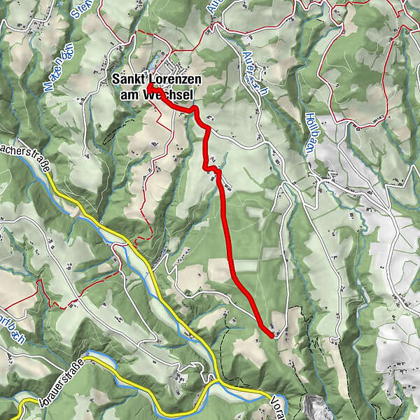
Searching for traces in the Roman Forest, St. Lorenzen am Wechsel

Chemin thématique

© Oststeiermark Tourismus - Flotoanker

© Oststeiermark Tourismus - Freizeitzentrum Römerhütte

© Oststeiermark Tourismus - Freizeitzentrum Römerhütte

© Oststeiermark Tourismus - Freizeitzentrum Römerhütte

© Oststeiermark Tourismus - Freizeitzentrum Römerhütte

© Oststeiermark Tourismus - Freizeitzentrum Römerhütte

© Oststeiermark Tourismus - Freizeitzentrum Römerhütte
- Brève description
-
On this hike through the fragrant meadows and colorful forests of the southern Wechsel region, you can enjoy beautiful views of Vorau Abbey, Güssing Castle, nearby Burgenland and the Fischbach Alps.
- Difficulté
-
facile
- Évaluation
-
- Parcours
-
Sankt Lorenzen am Wechsel0,2 kmRömerhütte4,0 km
- Meilleure saison
-
janv.févr.marsavrilmaijuinjuil.aoûtsept.oct.nov.déc.
- Hauteur maximale
- 738 m
- Point de mire
-
Recreation center Römerhütte, St. Lorenzen am Wechsel
- Profil en hauteur
-


-

-
AuteurLa randonnée Searching for traces in the Roman Forest, St. Lorenzen am Wechsel est utilisé par outdooractive.com fourni par.
GPS Downloads


Informations générales
Point de rassemblement
Culturel/Historiquement
Faune
Prometteur
Autres parcours dans les régions
-
Wiener Alpen
3048
-
Kräuterregion Wechselland
1085
-
St. Lorenzen am Wechsel
250