© Schöneck Tourismus - J&J

- Brève description
-
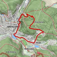
The hiking tour leads from Schöneck down to Schilbach and over the Bockmühle and the valley station of the 4-seater chairlift back to the starting point. It is marked green throughout and signposted "Innerer Ringweg".
- Difficulté
-
moyen
- Évaluation
-
- Parcours
-
Kinderspielplatz, Am Sohr0,2 kmSchöneck0,4 kmFreizeitpark Haselmühle1,2 kmSchilbach4,1 kmZum Hüttenwirt8,3 kmSportlerheim Schöneck10,3 kmSchöneck11,0 km
- Meilleure saison
-
janv.févr.marsavrilmaijuinjuil.aoûtsept.oct.nov.déc.
- Hauteur maximale
- 766 m
- Point de mire
-
Albertplatz Schoeneck
- Profil en hauteur
-
 © outdooractive.com

- Auteur
-
La randonnée Hike 1 - Inner Railway est utilisé par outdooractive.com fourni par.
GPS Downloads


Informations générales
Point de rassemblement
Prometteur
Autres parcours dans les régions
-
Vogtland / Sachsen
697
-
Schöneck
170