Hiver
Été
Météo
Webcams
Hébergements
Parcours
Historique des recherches
Suggestions de recherche
Aucun résultat trouvé
Rechercher
Bike
Accueil
Été Österreich
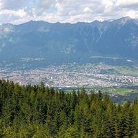
Tyrol
Innsbruck und seine Feriendörfer
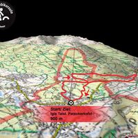
Patscherkofel - Igls
Parcours
Bike
Région
Hébergements
Météo
Webcams
Conseils loisirs
Parcours
Sport
Lacs
Photos
Vidéos
Offres
Forum
Station de ski
Bike
Patscherkofel - Igls
Carte
afficher
masquer
Filtrer les parcours
Type de parcours
(Tout)
VTT (153)
E-MTB (18)
Vélo de course (13)
Faire du vélo (6)
E-Bike (1)
Piste cyclable longue distance (1)
Recherche mot complet
Endurance
min.
1 facile
2 moyen
3 de difficulté moyenne
4 difficile
5 très difficile
6 extrême
max.
1 facile
2 moyen
3 de difficulté moyenne
4 difficile
5 très difficile
6 extrême
Technique
min.
1 facile
2 moyen
3 de difficulté moyenne
4 difficile
5 très difficile
6 extrême
max.
1 facile
2 moyen
3 de difficulté moyenne
4 difficile
5 très difficile
6 extrême
Longueur (km)
Dénivelée
autres filtres
Rechercher
Réinitialiser
192 Parcours.
classé par
Relevanz
Pertinence
längste Distanz
kürzeste Distanz
durée la plus longue
durée la plus courte
le plus grand nombre de mètres d'altitude
le moins de dénivelé
grande condition physique
faible condition physique
haute technicité
technique basse
Nom de A à Z
Nom Z-A
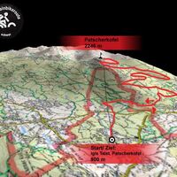
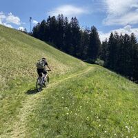
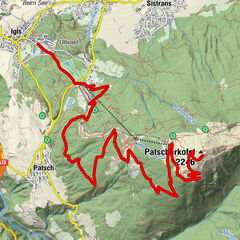
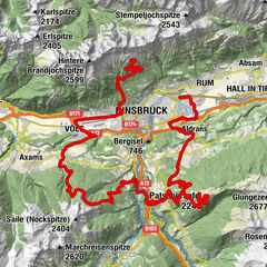
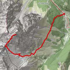
Innsbruck/ Igls: Patscherkofel
VTT
4,0
14,13
km
03:30
h
1.469
hm
908 - 2.235
m
Technique
Endurance
Arztal mit Trails
difficile
VTT
55,57
km
04:50
h
1.575
hm
560 - 1.902
m
Technique
Endurance
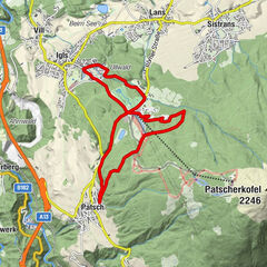
Igls: Patscherkofel-Rundkurs
moyen
VTT
9,5
km
01:30
h
340
hm
-
Technique
Endurance
Lanser Alm, Innsbruck, Tirol Innsbruck, Tirol
moyen
VTT
19,41
km
01:57
h
826
hm
928 - 1.708
m
Technique
Endurance
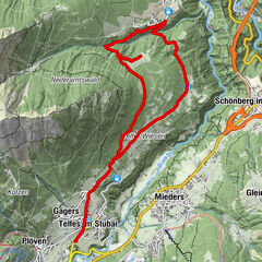
Telfes Stollensteig
difficile
VTT
50,98
km
04:13
h
1.176
hm
566 - 1.085
m
Technique
Endurance
Innsbrucker MTB-Karussell Innsbruck, Tirol
difficile
VTT
76,15
km
04:13
h
3.642
hm
567 - 2.190
m
Technique
Endurance
Sistranser Alm
moyen
E-MTB
36,3
km
02:00
h
994
hm
573 - 1.602
m
Technique
Endurance
Maria Waldrast
moyen
VTT
11,1
km
02:00
h
700
hm
1.013 - 1.638
m
Technique
Endurance
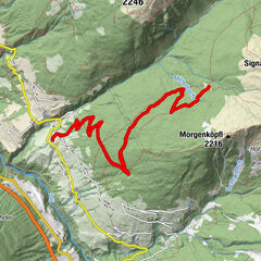
556 König Serles
VTT
1,0
23,01
km
02:45
h
900
hm
-
Technique
Endurance
GH Koppeneck
moyen
VTT
12,3
km
02:00
h
650
hm
1.013 - 1.650
m
Technique
Endurance
556 Serlesblick
VTT
18,67
km
02:31
h
633
hm
948 - 1.668
m
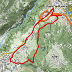
557 Zauberwald Runde
VTT
6,65
km
00:48
h
156
hm
956 - 1.113
m
5071 Stockerhof
VTT
13,22
km
01:48
h
389
hm
971 - 1.242
m
Moutainbike - Tour Profeglalm
moyen
VTT
15,35
km
03:45
h
663
hm
1.071 - 1.813
m
Technique
Endurance
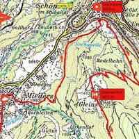
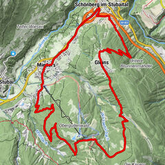
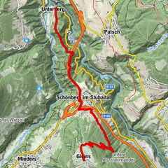
504 Gleins
VTT
8
km
02:05
h
656
hm
714 - 1.422
m
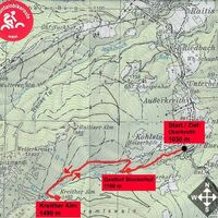
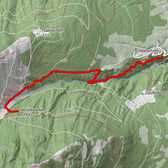
Innsbruck - Kreither Alm
VTT
3,3
3,6
km
01:15
h
467
hm
1.014 - 1.495
m
Technique
Endurance
Mieders - Mutters (Bike Trail Tirol)
VTT
20,6
km
03:30
h
901
hm
-
Technique
Endurance
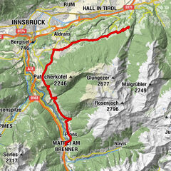
Transalp - Sektion Hall - Brenner
moyen
VTT
38,09
km
05:06
h
933
hm
559 - 1.082
m
Technique
Endurance
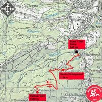
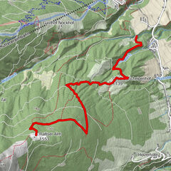
Innsbruck - Raitiser Alm
VTT
4,3
km
01:30
h
573
hm
941 - 1.539
m
Technique
Endurance
Windegg - Matrei (Bike Trail Tirol)
VTT
27,38
km
03:00
h
521
hm
-
Technique
Endurance
Pages:
1
2
3
4
5
6
7
8
suivant
Parcours par type
Randonnée
Bike
Hiver
Fonctionnement
Alpin
VTT
E-MTB
Vélo de course
Faire du vélo
E-Bike
Piste cyclable longue distance
Randonnées populaires dans la région
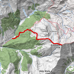
Naviser Kreuzjöchl (2.536m)
moyen
Ski de randonnée
4,8
km |
1080
hm |
03:00
h
Largoz – circuits à ski pour tout l’hiver - Volders
moyen
Ski de randonnée
3,3
km |
812
hm |
03:00
h
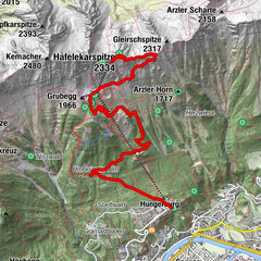
von Hungerbahn auf Hafelekarspitze
moyen
Randonnée
9,72
km |
1519
hm |
03:53
h
Serles (2.717m)
moyen
Randonnée
8,79
km |
1034
hm |
04:30
h
Voisin
Igls
Patsch
Lans
Sistrans
Aldrans
Régions favorite
Innsbruck
Lienz
Kufstein
Reutte
Imst
Tannheimer Tal
Neustift im Stubaital
Schwaz
Längenfeld - Huben - Gries
Ischgl
Telfs
Seefeld in Tirol
Matrei in Osttirol
Kals am Großglockner
Leutasch
Wörgl
Kaltenbach
Hall in Tirol
Umhausen im Ötztal
Jenbach
Jeu-concours
Produkt-Paket für die ganze Familie
Primavera XXL-Gewinnspiel
Aucune entrée trouvée.
La recherche n'est actuellement pas disponible.
Veuillez affiner votre recherche.
Résultats de recherche locaux
(<= 25km)
Plus de résultats
(> 25km)
%count% Résultat de la recherche
%name%
%type%
%elevation%
%population%
%lpButton%