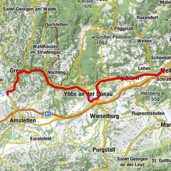
Danube Cycle Path Stage 4 North Bank: Grein - Emmersdorf

Piste cyclable longue distance
© WGD Donau Oberösterreich Tourismus GmbH/Erber

© WGD Donau Oberösterreich Tourismus GmbH/Erber

© WGD Donau Oberösterreich Tourismus GmbH/Erber - Erber

© Donau Niederösterreich, Robert Herbst

© Donau Niederösterreich, Robert Herbst

© Donau Niederösterreich, Klaus Engelmayer

© Donau Niederösterreich, Robert Herbst

- Brève description
-
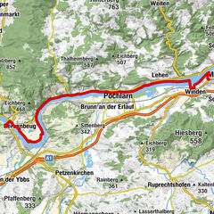
Attention: The Danube cycle path will be renovated until April 2021 in the area Marbach (Krummnußbaum/DuB) - Klein-Pöchlarn and largely diverted in Persenbeug on the south bank to Ybbs and from there to Pöchlarn. Cyclists directly approaching the construction site will be diverted to the B3 in Krummnußbaum/DuB and back to the Treppelweg in the area of Klein-Pöchlarn.
- Difficulté
-
facile
- Évaluation
-
- Parcours
-
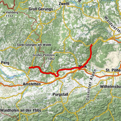
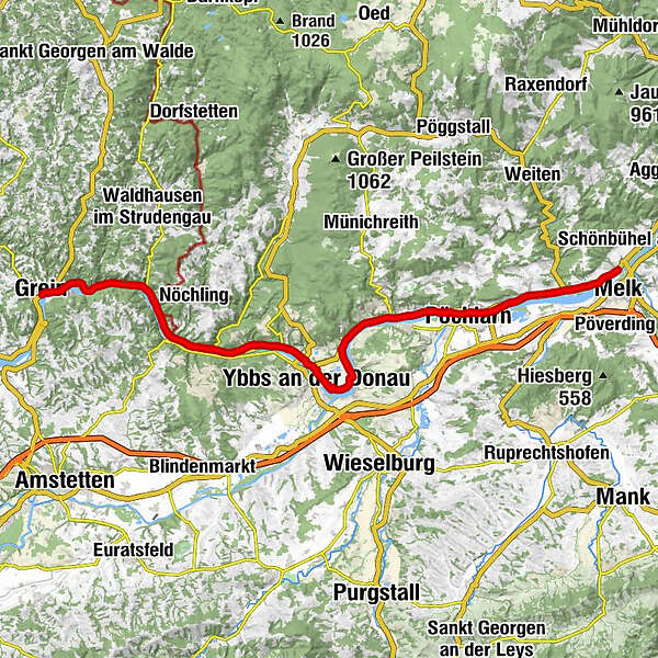
GreinKalvarienbergkapelle0,3 kmHalterkreuz0,3 kmHößgang1,6 kmStruden3,2 kmHaussteinkapelle3,6 kmSt. Nikola an der Donau4,1 kmNikolauskirche Sankt Nikola4,2 kmKiliankirche Sarmingstein6,5 kmSarmingstein6,9 kmStrudengauhof7,0 kmSarmingstein7,1 kmSchiffsanlegestelle7,5 kmHirschenau9,7 kmYsperdorf13,4 kmGasthof Hinterleithner15,1 kmKapelle Weins15,6 kmWeins15,7 kmFahrenbach17,7 kmFloriani-Kapelle19,9 kmGasthof Böhm20,0 kmPersenbeug20,4 kmYbbs an der Donau21,1 kmHagsdorf22,1 kmGottsdorf25,2 kmFischwirtshaus Landmotel Die Donaurast26,1 kmMetzling26,1 kmLoja26,6 kmDiedersdorf26,9 kmPizzeria Rialto28,8 kmGranz28,9 kmZur alten Fähre29,2 kmMarbach an der Donau29,6 kmLandgasthof "Zur schönen Wienerin"29,6 kmWachauerhof30,5 kmKrummnußbaum an der Donauuferbahn31,2 kmJohny's Jungle31,2 kmPöchlarn34,2 kmPizzeria LaLuna34,8 kmKlein-Pöchlarn34,8 kmEbersdorf38,2 kmLehen38,6 kmUrfahr39,9 kmWeitenegg40,9 kmWirtshaus Gruber41,0 kmHafenstüberl Luberegg41,8 kmSankt Georgen42,1 kmHain42,1 kmLuberegg42,3 kms'Felsengartl43,8 kmEmmersdorf an der Donau44,4 km
- Meilleure saison
-
janv.févr.marsavrilmaijuinjuil.aoûtsept.oct.nov.déc.
- Hauteur maximale
- 246 m
- Point de mire
-
Emmersdorf
- Profil en hauteur
-


- Auteur
-
La randonnée Danube Cycle Path Stage 4 North Bank: Grein - Emmersdorf est utilisé par outdooractive.com fourni par.
GPS Downloads


Informations générales
Point de rassemblement
Culturel/Historiquement
Flore
Autres parcours dans les régions