- Brève description
-
The 7.6 km long circular walk via Blümelsberg and back to the monastery in Seitenstetten provides a beautiful view of Seitenstetten and the surrounding communities.
- Difficulté
-
facile
- Évaluation
-
- Parcours
-
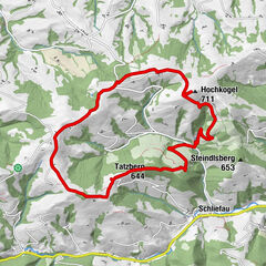
SeitenstettenWildheuriger Kronawetter3,1 kmBlümelsberg (527 m)3,5 kmSeitenstetten7,2 km
- Meilleure saison
-
janv.févr.marsavrilmaijuinjuil.aoûtsept.oct.nov.déc.
- Hauteur maximale
- 515 m
- Profil en hauteur
-

- Auteur
-
La randonnée Panoramablick (Mostobstwanderweg) est utilisé par outdooractive.com fourni par.
GPS Downloads


Informations générales
Point de rassemblement
Prometteur
Autres parcours dans les régions
-
Traunviertel
1940
-
Moststraße
754
-
Seitenstetten
181