© Engelberg-Titlis Tourismus - Engelberg - Titlis Tourismus

© Engelberg-Titlis Tourismus - Engelberg - Titlis Tourismus

© Engelberg-Titlis Tourismus - Engelberg - Titlis Tourismus

© Outdooractive – 3D Videos

- Brève description
-
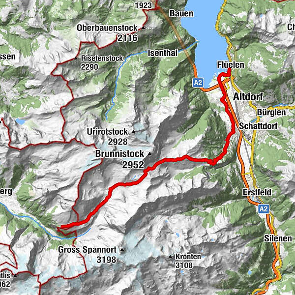
The day hike from Engelberg over the Surenen Pass to Attinghausen is one of the most impressive routes in Central Switzerland. Enjoy a unique view of the snow-covered Titlis and the surrounding mountains. On the other side of the pass, a magnificent view of the Lake of Uri and the Reuss valley awaits you.
- Difficulté
-
difficile
- Évaluation
-
- Parcours
-
FürenalpStäuberfall II3,3 kmStäuberfall I3,4 kmBlackenalp5,2 kmRüteli13,6 kmAlp Catrina13,6 kmBrüsti14,1 kmBerggasthaus Brüsti14,1 kmHöhiberg14,8 kmRösti16,8 kmMettlen17,5 kmBurglihofstatt17,5 kmCholplatz17,8 kmRibi17,9 kmHäldi18,1 kmAttinghausen (468 m)18,4 kmUntere Postmatte18,9 kmBalankamatt20,7 kmSeedorf UR (452 m)21,0 kmFlüelen (436 m)24,2 kmFlüelen (435 m)24,4 km
- Hauteur maximale
- 2.284 m
- Profil en hauteur
-
 © outdooractive.com


-

-
AuteurLa randonnée Surenenpass est utilisé par outdooractive.com fourni par.
GPS Downloads

Autres parcours dans les régions
-
Uri
1553
-
Urner Unterland
866
-
Attinghausen
185