From Pranzaira to the Albigna hut

Logo From Pranzaira to the Albigna hut
Dates des itinéraires
9,75km
1.194 - 2.324m
Distance
202hm
1.059hm
Montée
03:00h
 
Durée
Brève description

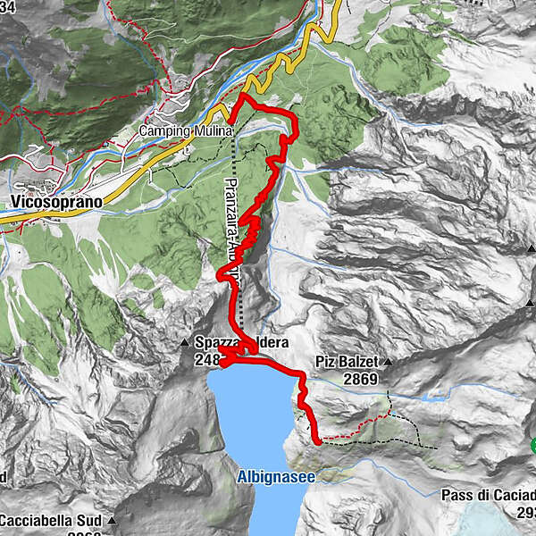
You can reach the refuge with a short walk of just over half an hour if you use the small mountain railway. The complete hike from Pranzaira takes about 3 hours.

Difficulté
moyen
Évaluation
Technique
Endurance
Paysage
Résultat
Parcours
Albigna (2.100 m)
Albigna (1.315 m)
2,2 km
Albignahütte
2,2 km
Pranzaira
9,6 km

Meilleure saison
janv.
févr.
mars
avril
mai
juin
juil.
août
sept.
oct.
nov.
déc.
Hauteur maximale
2.324 m
Point de mire

Pranzaira

Profil en hauteur
© outdooractive.com

Auteur
La randonnée From Pranzaira to the Albigna hut est utilisé par outdooractive.com fourni par.

Évaluation globale

5

0

%

4

0

%

3

0

%

2

0

%

1

0

%

Erreur
Une erreur est survenue. Veuillez réessayer.
Merci pour votre évaluation

L'évaluation a été supprimée

GPS Downloads
  • GPX GPS Exchange Format (XML)
  • KML Google Earth, Google Maps
Codes de téléchargement QR pour les téléphones portables

Informations générales

Point de rassemblement
Prometteur
Autres parcours dans les régions

Randonnées populaires dans la région

Radons - Tga / Val Faller

moyen Randonnée
14,21km | 717hm | 05:00h

Col du Julier - Fuorcla Grevasalvas - Sils

difficile Randonnée
10,74km | 431hm | 03:55h

Circuit Bondo - Castasegna - Soglio

moyen Randonnée
10,07km | 370hm | 03:30h

Bergtour: Bernina-Tour im Engadin, Etappe 5

moyen Randonnée
14,52km | 48hm | 04:00h