


© Interlaken Tourismus - Mike Kaufmann

© Interlaken Tourismus - Mike Kaufmann

© Interlaken Tourismus - Mike Kaufmann

- Brève description
-
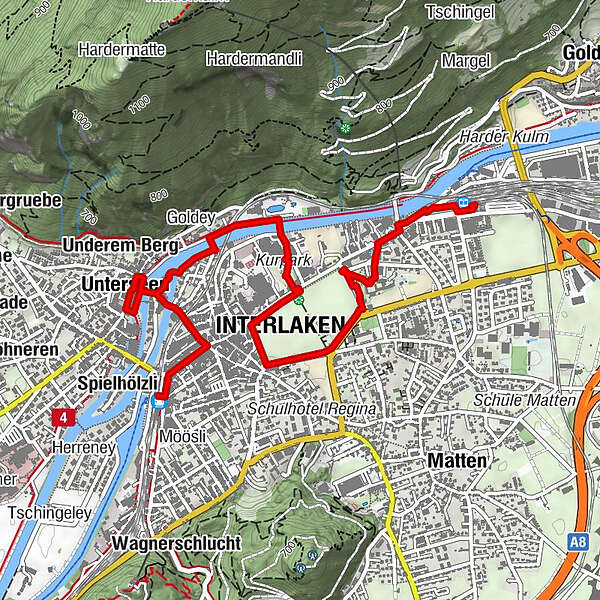
This walk through Interlaken takes you to the English and Japanese gardens and the Interlaken monastery before circling the Höhematte, crossing the River Aare and calling at the town hall square of Unterseen.
- Difficulté
-
facile
- Évaluation
-
- Parcours
-
Interlaken Ost (567 m)0,1 kmHeiliggeist0,6 kmSchlosskirche0,7 kmGruebi1,4 kmInterlaken (568 m)1,9 kmUsseri Zälg2,3 kmAarzälg2,6 kmGoldey2,7 kmUnterseen (567 m)3,2 kmUnderem Berg3,3 kmStedli3,4 kmSpielmatte3,6 kmBleikimatta3,9 kmHübeli4,0 kmArmüli4,1 kmInterlaken West (564 m)4,1 kmSpielhölzli4,3 km
- Meilleure saison
-
janv.févr.marsavrilmaijuinjuil.aoûtsept.oct.nov.déc.
- Hauteur maximale
- 569 m
- Point de mire
-
Railway station Interlaken West
- Profil en hauteur
-
 © outdooractive.com


- Auteur
-
La randonnée Interlaken walkabout est utilisé par outdooractive.com fourni par.
GPS Downloads


Informations générales
Point de rassemblement
Culturel/Historiquement
Prometteur
Autres parcours dans les régions
-
Aletsch Arena
1485
-
Interlaken
1112
-
Interlaken - Matten - Unterseen
469


