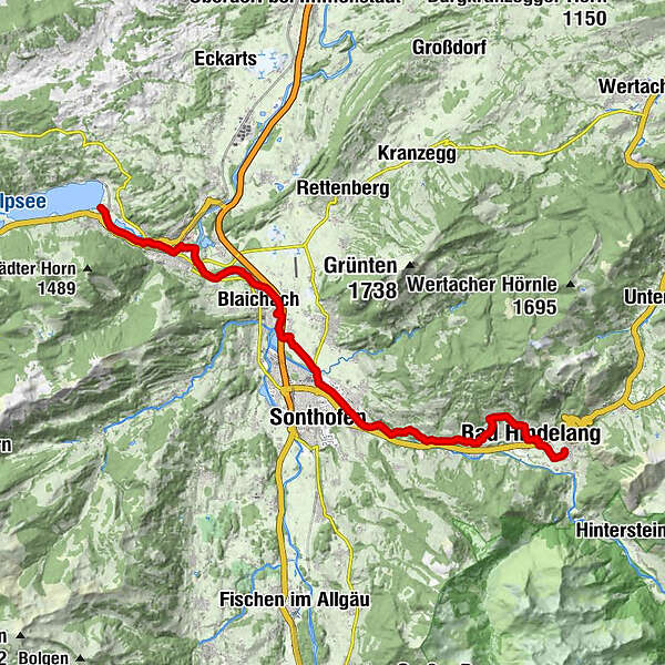
St. James way Section 6 Bad Hindelang- Immenstadt/Bühl

Chemin de pèlerinage


- Brève description
-
A panoramic and culturally very interesting stage with charming hamlets and idyllic riverside paths.
- Difficulté
-
moyen
- Évaluation
-
- Parcours
-
St. JodokusBad Oberdorf0,1 kmPfarrkirche Johannes der Täufer1,5 kmBad Hindelang (825 m)1,6 kmSt. Sylvester2,9 kmGailenberg3,0 kmVorderhindelang4,3 kmReckenberg5,5 kmTiefenbach6,8 kmSt. Sebastian6,8 kmStaig7,9 kmBinswangen8,4 kmSonthofen (741 m)9,7 kmErzflöße10,7 kmMaria Trost12,0 kmOrtwang12,2 kmSteakhouse13,5 kmBlaichach14,2 kmHofen14,9 kmAltmummen16,3 kmÖlbergkapelle18,6 kmSankt Nikolaus18,6 kmImmenstadt i.Allgäu (729 m)18,6 kmGasthaus zum Alpsee21,0 kmBühl a.Alpsee21,0 km
- Meilleure saison
-
janv.févr.marsavrilmaijuinjuil.aoûtsept.oct.nov.déc.
- Hauteur maximale
- 979 m
- Point de mire
-
Immenstadt - Bühl
- Profil en hauteur
-
 © outdooractive.com


- Auteur
-
La randonnée St. James way Section 6 Bad Hindelang- Immenstadt/Bühl est utilisé par outdooractive.com fourni par.
GPS Downloads


Informations générales
Point de rassemblement
Culturel/Historiquement
Flore
Faune
Prometteur
Autres parcours dans les régions
-
Allgäu
2365
-
Alpsee-Grünten
1691
-
Burgberg
409